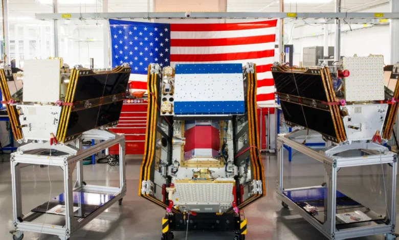
As thick smoke from hundreds of raging wildfires continued to blanket vast swathes of Canada and the United States in July 2026, a significant leap in environmental monitoring was achieved with the successful launch of the first three operational satellites in the Google-backed FireSat program. These advanced microsatellites, launched aboard a SpaceX Falcon 9 rocket from Vandenberg Space Force Base in California on July 7, 2026, herald a new era in wildfire detection, promising to spot even nascent blazes that traditional systems often miss. Following a rigorous three-month testing phase, these initial satellites are expected to commence active data provision to fire agencies across the United States, Australia, and Europe before the close of the year, marking a critical transition to "initial operational capability" for the FireSat constellation.
The FireSat Constellation: A New Era in Wildfire Detection
Managed by the nonprofit Earth Fire Alliance, the FireSat program is distinguished as the first satellite constellation purpose-built specifically for wildfire detection. Its core mission is to provide unprecedented early warning capabilities, particularly for smaller fires that frequently escalate into uncontrollable infernos before they are noticed by existing, less specialized satellite systems. The technology underpinning FireSat represents a significant advancement, designed to pierce through environmental obscurities that have historically hampered effective wildfire surveillance.
The Technology Behind FireSat
Each FireSat satellite is equipped with cutting-edge multispectral imaging technology, a crucial innovation enabling it to peer effectively through dense smoke plumes and cloud cover. Unlike conventional optical satellites that rely on visible light, FireSat utilizes a broader range of the electromagnetic spectrum, including thermal infrared wavelengths. This allows the satellites to detect the heat signatures emitted by fires, even when the flames themselves are obscured from direct view. This capability is paramount for early detection, as it can identify fires as small as five by five meters—approximately 16 by 16 feet—a size often invisible to other monitoring platforms.
The efficacy of this technology was unequivocally demonstrated by a FireSat Protoflight satellite, which launched in March 2025. During its testing phase, this prototype collected over one million images, proving its ability to detect low-intensity blazes that existing satellites simply could not see. This successful validation paved the way for the deployment of the operational constellation, confirming the program’s potential to provide actionable intelligence to firefighting teams when every minute counts. The use of microsatellites also contributes to the program’s agility and cost-effectiveness, allowing for more rapid deployment and a larger constellation size compared to traditional, larger satellites.
Key Players and Funding
The development and deployment of the FireSat constellation are a collaborative effort backed by significant financial and technical support from leading organizations. California-based satellite manufacturer Muon Space designed and built the sophisticated microsatellites, leveraging their expertise in space technology to create a robust and reliable platform.
Financial backing has been substantial, underscoring the perceived importance and potential impact of the FireSat initiative. Google has committed over $15 million to support the initial deployment, reflecting the tech giant’s growing interest in leveraging artificial intelligence and advanced technology for climate resilience. Google’s involvement extends beyond mere funding, with its research arm playing a pivotal role in developing the analytical tools necessary to maximize the utility of the satellite data. Further bolstering the program’s financial foundation, the Bezos Earth Fund, a philanthropic initiative by Amazon founder Jeff Bezos, has pledged an impressive $26 million. This commitment aligns with the fund’s broader focus on combating climate change and protecting nature through innovative solutions. The Earth Fire Alliance, a dedicated nonprofit, oversees the management and strategic direction of the constellation, ensuring its data reaches the fire agencies most in need.

Phased Deployment and Future Vision
The launch of the first three operational satellites marks a critical milestone, but it is merely the beginning of an ambitious deployment schedule. After the initial three-month testing period, data will be actively supplied to early adopter organizations, including fire agencies in California, Colorado, Australia, and Portugal. These regions, frequently ravaged by wildfires, will serve as crucial testbeds for integrating FireSat data into their operational responses.
The Earth Fire Alliance has outlined an aggressive expansion plan for the constellation. As more satellites are launched, the program aims to provide the latest imagery anywhere in the world on an hourly basis by 2029. The ultimate goal is to achieve near real-time surveillance, with imagery becoming available every 20 minutes once the full constellation of more than 50 satellites is launched by the early 2030s. This rapid revisit rate would offer an unprecedented level of situational awareness, allowing fire managers to track the inception and spread of wildfires with extraordinary precision and speed.
The Urgency: Escalating Global Wildfire Crisis
The urgency driving the FireSat program is rooted in the escalating global wildfire crisis, a phenomenon intrinsically linked to climate change. Wildfires are becoming more frequent, more intense, and burning larger areas across the globe, posing increasing threats to ecosystems, economies, and human lives.
Climate Change as a Catalyst
For decades, climate and forest scientists have warned about the trajectory of global warming and its profound impact on wildfire regimes. Hotter, drier conditions, extended periods of drought, and earlier snowmelt contribute to increased fuel loads and longer fire seasons, creating ideal conditions for wildfires to ignite and spread rapidly. The Intergovernmental Panel on Climate Change (IPCC) has consistently highlighted the direct correlation between anthropogenic greenhouse gas emissions and the observed increase in extreme fire weather. Regions such as the Mediterranean Basin, parts of South America, and vast boreal forests, in addition to North America and Australia, are experiencing unprecedented fire activity. For instance, the Mediterranean has seen a significant increase in megafires, with devastating seasons in Greece, Turkey, and Italy becoming increasingly common.
Economic and Environmental Devastation
The consequences of this escalating crisis are far-reaching. The Earth Fire Alliance has projected that even an hourly revisit rate from the FireSat constellation could lead to substantial benefits, including saving more than $1 billion in fire damage costs annually. This figure encompasses direct property losses, infrastructure damage, and agricultural devastation. Beyond financial costs, the environmental impact is profound: early detection could prevent nearly 22 million tons of carbon emissions, reducing the feedback loop where wildfires release stored carbon, further exacerbating global warming. Moreover, the program estimates it could protect 3,500 homes and safeguard 1.3 million acres of land from destruction. These projections underscore the immense value proposition of proactive wildfire management.
Humanitarian Impact and Evacuations

The human toll of wildfires is equally dire. The summer of 2026 saw Canadian wildfires spread vast plumes of smoke across North America, forcing thousands of people, particularly in vulnerable First Nations communities, to evacuate their homes. The hazardous air pollution inflicted by this smoke affected more than 100 million people across Canadian and US cities, leading to spikes in respiratory illnesses, emergency room visits, and a general decline in public health. The Canadian Wildland Fire Information System reported nearly 900 active wildfires in Canada as of July 17, 2026, with over 3,600 wildfires recorded year-to-date, burning more than 6.6 million acres—an area larger than several European countries. This follows two of Canada’s most destructive wildfire seasons in 2023 and 2025, with the last three years consistently ranking among the ten worst on record.
Werner Kurz, a retired senior research scientist at Natural Resources Canada, succinctly captured the gravity of the situation, telling The Atlantic, "What is unfolding is what climate and forest scientists have been predicting for 30 years. That as the world gets hotter and drier, we are exposing forests to more and more risk, and the old strategies of fire suppression are simply being overwhelmed."
AI’s Role and the Paradox of Digital Infrastructure
Google’s significant investment in FireSat is deeply intertwined with its advancements in artificial intelligence, positioning AI as a critical tool in the fight against climate change. However, this commitment also highlights a growing paradox: the very technologies deployed for climate resilience often carry their own substantial environmental footprint.
Google’s AI-Powered Analytics
Google Research plans to leverage its sophisticated AI models to maximize the utility of the FireSat data. This involves comparing the real-time operational FireSat data with vast archives of historical satellite imagery to accurately identify even very small fires. AI algorithms can detect subtle patterns and anomalies that might elude human observers, reducing false positives and accelerating the confirmation of active blazes. Furthermore, these AI models will be crucial for informing predictive modeling of wildfires, helping agencies anticipate fire behavior, spread trajectories, and potential impacts. Google celebrated the launch of the first operational FireSat satellites by describing the event as "another tangible step forward in putting practical AI to work for climate resilience," signaling its belief in technology’s power to address global challenges.
The Unseen Environmental Footprint of AI
Yet, the rapid expansion and deployment of newer AI models come with considerable climate costs. The infrastructure required to power advanced AI—specifically, large AI data centers—demands massive amounts of electricity. A significant portion of this energy demand is currently being met by new natural gas projects, particularly in the United States. Analysis suggests that the greenhouse gases emitted from the data center boom could collectively outpace the emissions of entire nations, potentially emitting more than 129 million tons of greenhouse gases per year. Google itself has publicly acknowledged the immense challenges of deploying enough clean energy projects to offset the surging electricity consumption of its energy-hungry data centers. The company reported a 37 percent increase in its company-wide electricity usage in 2025, largely driven by its aggressive AI buildout. This creates a complex scenario where technology designed to mitigate climate impacts simultaneously contributes to the very problem it seeks to solve, highlighting the need for sustainable AI development and energy sourcing.
Beyond Detection: Comprehensive Wildfire Management
While Google’s financial and technical support for AI-powered wildfire detection through FireSat is undeniably helpful, it is crucial to recognize that detection is but one element within a multifaceted approach necessary to prevent blazes from spiraling out of control. Effective wildfire management requires a comprehensive strategy that extends far beyond early warning systems.

Limitations of Detection Alone
Fire agencies, even with the most advanced detection capabilities, require adequate resources for proactive ecosystem management and robust fire suppression efforts. This includes implementing prescribed burns, a vital tool for reducing hazardous fuel loads in forests and grasslands, thereby preventing larger, more intense wildfires. However, such controlled burns require significant planning, resources, and favorable weather conditions, which are becoming scarcer due to global warming. Moreover, the fundamental job of putting out unwanted fires—active suppression—has become increasingly challenging as climate change fosters conditions conducive to rapid fire spread and extreme fire behavior.
Challenges in Fire Suppression
Traditional fire suppression methods have proven increasingly inadequate, particularly in vast and remote areas like Canada’s boreal forests. Fighting wildfires in these mostly uninhabited regions demands specialized, high-cost resources, including fixed-wing air tankers capable of dropping thousands of gallons of fire retardant, and heavy-lift helicopters for water drops and transporting firefighting crews to remote sites. The acquisition and maintenance of such aerial firefighting assets often fall to individual Canadian provinces, leading to resource strains. In recent years, every available aircraft has frequently been pressed into service, sometimes still proving insufficient. In response to these overwhelming seasons, the Canadian government in May 2026 leased 10 new aerial firefighting aircraft, making them available as "surge assets" for provinces facing critical situations.
The sheer scale of the ongoing crisis underscores the limitations. As of mid-July 2026, with nearly 900 active wildfires in Canada, dozens were classified as "out of control" and were simply being monitored rather than actively suppressed. This difficult decision reflects the grim reality faced by fire agencies globally: when resources are limited and risks to firefighters’ lives are too high, they are often forced to prioritize and concede certain areas to the fire’s natural progression. This highlights the urgent need not only for better detection but also for significantly enhanced capacity in prevention, active suppression, and strategic land management.
Conclusion: A Step Towards Resilience, Awaiting Broader Solutions
The launch of the FireSat constellation marks a pivotal advancement in humanity’s ongoing struggle against the escalating threat of wildfires. By offering unparalleled early detection capabilities through multispectral imaging and AI-powered analytics, it provides fire agencies with a vital new tool to respond more quickly and effectively, potentially saving lives, homes, and vast ecosystems. The significant backing from Google and the Bezos Earth Fund underscores a growing recognition among technological and philanthropic leaders of the urgent need for innovative climate solutions.
However, FireSat, while revolutionary, is not a panacea. It represents a crucial step towards climate resilience, yet it operates within a broader context of worsening environmental conditions driven by unchecked greenhouse gas emissions. The paradox of AI’s energy consumption highlights the complex challenges inherent in developing sustainable technological solutions. Ultimately, effective wildfire management demands a holistic approach that integrates advanced detection with robust prevention strategies, sufficient suppression resources, sound land management policies, and, critically, a global commitment to drastically reduce the fossil fuel emissions that continue to fuel a hotter, drier world. FireSat offers a clearer view through the smoke, but the path to truly extinguishing the wildfire crisis requires a far more comprehensive and collective effort.