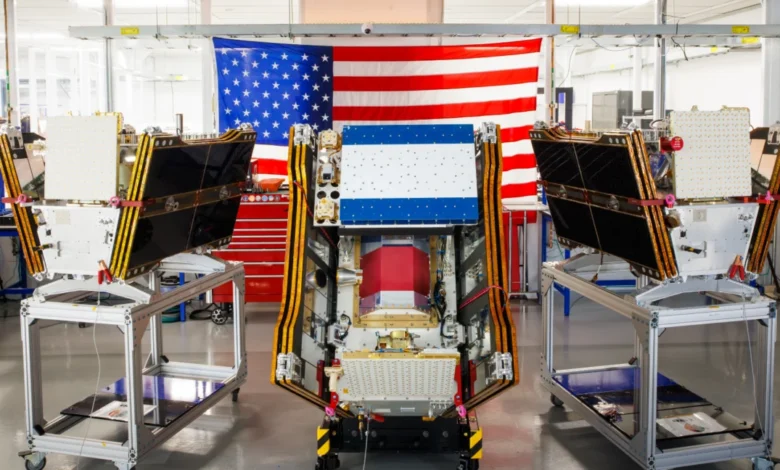
As vast plumes of smoke from hundreds of raging wildfires continue to blanket regions across Canada and the United States, a significant stride in global wildfire detection has been achieved with the successful launch of the first three operational satellites in the Google-backed FireSat program. These advanced microsatellites, designed to provide unparalleled wildfire detection capabilities, are poised to begin spotting even nascent blazes in the United States, Australia, and Europe before the close of the year, marking a critical juncture in humanity’s fight against escalating infernos.
A New Era in Wildfire Detection Takes Flight
The launch, executed by a SpaceX Falcon 9 rocket from Vandenberg Space Force Base in California on July 7, 2026, represents a pivotal moment for the FireSat constellation. This deployment signals the transition to "initial operational capability" for the program, which is managed by the nonprofit Earth Fire Alliance. Following a rigorous three-month testing period, these inaugural satellites will commence actively supplying vital data to fire agencies worldwide, aiming to cover every fire-prone region on Earth with at least two daily passes.
This ambitious initiative positions FireSat as the first satellite constellation meticulously engineered and purpose-built solely for wildfire detection. Its design overcomes the limitations of existing satellite systems, which often struggle to identify smaller fires or penetrate dense smoke and cloud cover. The advanced capabilities of FireSat are a testament to the collaborative efforts behind its development, with California-based satellite manufacturer Muon Space leading the engineering. Financial backing has been substantial, with Google committing over $15 million towards the initial deployment. Further significant contributions include a $26 million pledge from the Bezos Earth Fund, underscoring the broad philanthropic and technological commitment to addressing the global wildfire challenge.
Technological Edge: Seeing Through the Haze

Each FireSat satellite is equipped with state-of-the-art multispectral imaging technology, a crucial innovation that enables it to peer through thick smoke and clouds – conditions that typically blind conventional satellite systems. This advanced imaging suite allows for the detection of fires as minuscule as five by five meters (approximately 16 by 16 feet). The efficacy of this technology was conclusively demonstrated by a FireSat Protoflight satellite, which launched in March 2025. During its mission, the Protoflight collected more than one million images, proving its capacity to identify low-intensity blazes that were completely invisible to existing satellite networks, thus validating the core premise of the FireSat program.
This ability to detect small, incipient fires is paramount. Wildfires, particularly in their early stages, are often easier to contain, preventing them from escalating into uncontrollable conflagrations. The current global wildfire monitoring infrastructure, largely reliant on larger, multi-purpose satellites, typically offers lower resolution and less frequent revisit times, leading to delayed detection, especially for smaller, remote fires. FireSat’s dedicated, higher-resolution, and eventually more frequent coverage aims to fill this critical gap, providing fire managers with timely intelligence to deploy resources effectively.
Projected Impact and Early Adopters
The Earth Fire Alliance has outlined compelling projections regarding the potential benefits of the FireSat constellation. Even an initial hourly revisit rate is anticipated to yield substantial dividends, including saving over $1 billion in fire damage costs, preventing nearly 22 million tons of carbon emissions, safeguarding 3,500 homes, and protecting 1.3 million acres of land annually. These figures highlight the immense economic, environmental, and social value of early and accurate wildfire detection.
A cohort of "early adopter" organizations has already been identified and will begin integrating FireSat data into their operations this year. These include fire agencies in California, Colorado, Australia, and Portugal – regions frequently besieged by devastating wildfires. As the constellation expands, the FireSat program aims to deliver hourly imagery globally by 2029. The ultimate vision entails a full constellation of more than 50 satellites by the early 2030s, providing imagery every 20 minutes, offering near real-time intelligence to fire management teams across the planet.
Google Research is set to amplify FireSat’s capabilities further by leveraging the company’s advanced AI models. These models will compare operational FireSat data with historical images to accurately identify very small fires and to inform predictive modeling of wildfire behavior. Google hailed the launch of the first operational FireSat satellites as "another tangible step forward in putting practical AI to work for climate resilience," underscoring its commitment to applying artificial intelligence to mitigate environmental challenges.

The Broader Wildfire Crisis: A Global Challenge
The urgency of the FireSat mission is underscored by the escalating global wildfire crisis, a phenomenon intrinsically linked to climate change. Wildfires are burning with unprecedented intensity, frequency, and geographic spread across the globe. The year 2023, for instance, saw Canada experience its worst wildfire season on record, with over 18 million hectares burned, displacing hundreds of thousands and sending smoke across continents. This trend continued into 2025 and 2026, with consecutive severe seasons. Australia has likewise faced devastating bushfire seasons, notably the "Black Summer" of 2019-2020, which burned over 24 million hectares and emitted vast quantities of carbon. Europe, too, has seen a marked increase in large-scale fires, particularly in the Mediterranean region.
The scientific consensus is clear: greenhouse gas emissions from human activities, predominantly the burning of fossil fuels, are driving global warming, creating hotter, drier conditions that are ideal for wildfires to ignite and spread rapidly. Werner Kurz, a retired senior research scientist at Natural Resources Canada, succinctly articulated this grim reality to The Atlantic, stating, "What is unfolding is what climate and forest scientists have been predicting for 30 years… That as the world gets hotter and drier, we are exposing forests to more and more risk, and the old strategies of fire suppression are simply being overwhelmed."
Climate Change and Forest Management: Overwhelmed Defenses
Traditional fire suppression strategies are increasingly proving inadequate in the face of these megafires. The current summer’s wildfires in Canada’s boreal forests serve as a stark illustration, forcing thousands of residents, including many from First Nations communities, to evacuate rapidly. These fires have generated suffocating smoke clouds that have traversed national borders, inflicting hazardous air pollution upon over 100 million people across Canadian and US cities. The Canadian Wildland Fire Information System reported nearly 900 active wildfires as of July 17, 2026, with the country having already experienced more than 3,600 wildfires burning over 6.6 million acres this year alone. Dozens of these fires are classified as "out of control" and are merely being monitored rather than actively suppressed – a grim decision fire agencies are forced to make when balancing limited resources against the inherent risks to firefighters’ lives.
Fighting wildfires in remote, often uninhabited forest regions necessitates specialized resources, including fixed-wing air tankers capable of dropping fire retardants and heavy-lift helicopters for transporting firefighting crews and equipment. However, the burden of acquiring and maintaining such expensive assets typically falls on individual Canadian provinces. In recent years, virtually every available aircraft has been pressed into service, highlighting a systemic capacity issue. Recognizing this deficit, the Canadian government in May 2026 leased ten new aerial firefighting aircraft, along with two support assets, to augment the national response capacity and provide surge capabilities to provinces. While a step forward, experts argue that this alone is not a comprehensive strategy, emphasizing the need for proactive forest management, including prescribed burns, to reduce fuel loads and create more resilient ecosystems.

The Paradox of Progress: AI’s Environmental Footprint
While Silicon Valley’s rapid development and deployment of new AI models, such as those powering FireSat, offer immense potential for societal benefit, this technological advancement is not without its own considerable climate costs. The burgeoning demand for larger and more powerful AI data centers requires massive amounts of electricity. In the United States, this demand is often being met by new natural gas projects, which could collectively emit more than 129 million tons of greenhouse gases annually, exacerbating the very climate change problem AI aims to help solve.
Google, a leading force in AI development and a key backer of FireSat, has openly acknowledged the challenges in deploying sufficient clean energy projects to offset the potential emissions from its energy-hungry data centers. The company’s electricity usage grew by a staggering 37 percent in 2025, driven in large part by its expanding AI infrastructure. This presents a complex ethical and practical dilemma: the tools developed to combat climate change simultaneously contribute to the problem through their energy demands. Therefore, while FireSat offers a crucial advancement in climate resilience, it also highlights the urgent need for a parallel focus on decarbonizing the digital infrastructure that underpins such innovations.
Looking Ahead: A Multi-pronged Approach
The launch of the FireSat constellation represents a monumental leap forward in wildfire detection, offering a critical new tool for fire agencies globally. Its ability to spot small fires through smoke, provide frequent updates, and integrate with AI for predictive modeling holds the promise of significantly reducing the scale and impact of wildfires.
However, FireSat, while powerful, is but one component of a holistic solution. The escalating global wildfire crisis demands a multi-pronged approach that extends beyond early detection. It necessitates increased investment in proactive forest management practices, such as prescribed burns and fuel reduction, to mitigate fire risk before it materializes. It requires robust and adequately resourced fire suppression capabilities, including specialized aerial assets and trained personnel. Most fundamentally, it demands aggressive and sustained global efforts to curb greenhouse gas emissions and address the root cause of climate change, which is driving the increased frequency and intensity of these destructive events. Only through such integrated strategies can humanity hope to effectively manage and ultimately mitigate the growing threat of wildfires in a warming world.