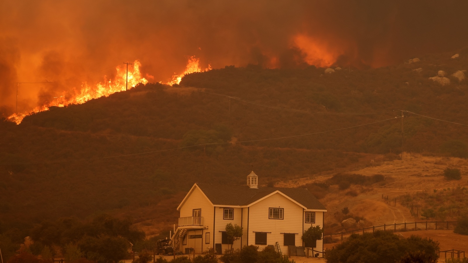
The global scientific community is facing a profound reckoning as two major studies reveal that the twin threats of sea-level rise and land subsidence have been systematically underestimated for decades. Real-world ocean data and high-resolution satellite mapping suggest that coastal flood risks are significantly more severe than current modeling predicts. In many of the world’s most populous regions, the land is sinking at rates that far outpace the rising ocean, creating a "perfect storm" of inundation that threatens the livelihoods of hundreds of millions of people. These findings, published by researchers at Wageningen University and the University of California, Irvine, suggest that the baseline for future flood risk is already much higher than previously thought, necessitating an urgent re-evaluation of global climate adaptation strategies.
A Massive Discrepancy in Sea-Level Baselines
For years, the international consensus on sea-level rise has been guided by mathematical models that calculate the "geoid"—the theoretical shape of the Earth’s surface if the oceans were at rest and influenced only by gravity and rotation. However, new research led by Katharina Seeger and Philip Minderhoud at Wageningen University & Research has exposed a critical flaw in this approach. By analyzing actual measurements from 385 tidal gauges worldwide, the researchers found that real-world sea levels are, on average, nearly one foot higher than these standard geoid-based estimates.
The discrepancy stems from the fact that global models often assume a "calm" ocean, ignoring the complex dynamics of currents, prevailing winds, and the thermal expansion of water in specific regions. In some cases, the researchers found that previously accepted sea-level baselines were off by three feet or more. This is not a matter of the sea rising faster than predicted, but rather a realization that the starting point—the current level of the ocean relative to the land—is much higher than scientists had calculated.
The implications of this finding are staggering. The study concludes that approximately 80 million people are currently living in coastal areas that are technically below sea level, nearly double the previous estimates. As sea levels continue to rise due to melting polar ice and warming oceans, these populations are at an immediate and heightened risk of flooding.
The Silent Threat of Land Subsidence
While the rising ocean captures most of the headlines, a second, perhaps more insidious threat is unfolding beneath the feet of coastal residents. Land subsidence—the literal sinking of the Earth’s surface—is occurring at an alarming rate in many of the world’s most vital river deltas. A study led by Leonard Ohenhen at the University of California, Irvine, utilized satellite-mounted radar to create high-resolution 3D maps of 40 of the world’s largest and most populous deltas.
The data revealed that more than half of these deltas are actively sinking. Most alarmingly, in 18 of the cases studied, the rate of land subsidence exceeds the rate of sea-level rise. In the most extreme instances, the land is sinking ten times faster than the ocean is rising. This effectively doubles or even decuples the local impact of sea-level rise, bringing the threat of permanent inundation decades closer than previously anticipated.
Subsidence is largely an anthropogenic phenomenon. The primary driver is the over-extraction of groundwater to support growing urban populations, industry, and agriculture. As water is pumped out of underground aquifers, the soil compacts and the surface settles. Additionally, the construction of dams and levees upstream prevents the natural flow of sediment to deltas. Without new layers of silt to replenish the land, the deltas naturally erode and sink.
A Chronology of Scientific Miscalculation
The realization that coastal vulnerability has been underestimated is the result of a multi-decade evolution in Earth science and monitoring technology.
- The Model Era (1990s–2010s): Early assessments of sea-level rise relied heavily on global mathematical models. Because high-quality tidal gauge data was historically concentrated in Europe and North America, these models were optimized for the Global North. This created a "methodological blind spot" for the Global South, where ocean dynamics are more volatile.
- The Satellite Revolution (2010s–Present): The advent of sophisticated satellite radar (InSAR) allowed scientists to measure minute changes in land elevation over vast areas. This technology provided the first clear evidence that cities like Jakarta and Bangkok were sinking at rates far beyond natural geological processes.
- The 2024–2025 Reckoning: The two new studies from Wageningen and UC Irvine represent the culmination of this data. By combining real-world tidal gauge measurements with high-resolution subsidence maps, researchers have finally bridged the gap between theoretical models and real-world observations.
Regional Impacts: From the Mekong to the Mississippi
The dual crisis of rising seas and sinking land is not distributed evenly. The Global South, particularly Southeast Asia and Africa, is bearing the brunt of these miscalculations.
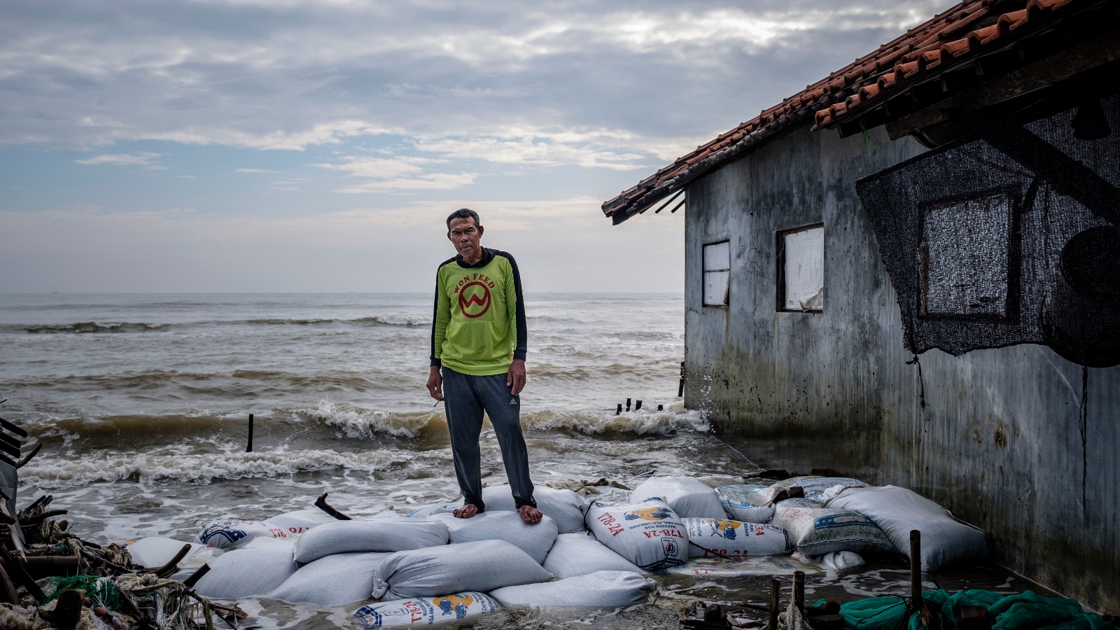
Southeast Asia: The Epicenter of Subsidence
In Indonesia, the city of Semarang is sinking so rapidly—up to 20 to 50 times the rate of sea-level rise—that entire neighborhoods are being abandoned to the waves. Jakarta, the nation’s capital, has sunk by as much as 13 feet since 1970, a reality that forced the Indonesian government to announce the relocation of its capital to the island of Borneo. In Vietnam, the Mekong Delta, which provides food for millions, is facing a similar crisis. Philip Minderhoud noted that while models suggested inundation would occur at 5 to 6 feet of sea-level rise, the actual surface water levels are already dangerously high, putting the region on the brink of collapse.
The Nile Delta: Egypt’s Agricultural Crisis
The Nile Delta, home to two-thirds of Egypt’s farmland, is being squeezed by the Aswan High Dam, which blocks sediment, and intensive groundwater pumping. The new analysis shows subsidence rates are much higher than previously reported, leading to saltwater intrusion that is poisoning crops and threatening the historic city of Alexandria.
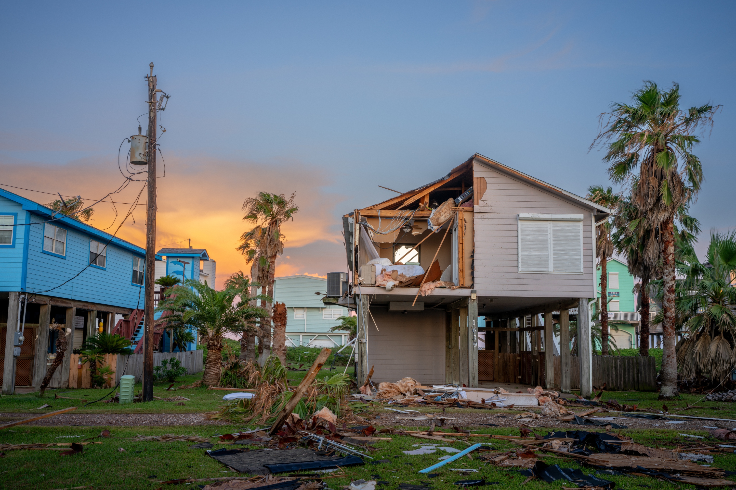
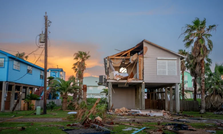
The Mississippi Delta: A North American Warning
In the United States, the Mississippi Delta has lost nearly 1,900 square miles of land over the last century. Levees designed to protect against floods have inadvertently caused the delta to sink by preventing the deposition of new sediment. The region continues to sink by an average of two inches per year, making it increasingly vulnerable to the devastating storm surges of Atlantic hurricanes.
Expert Reactions and Global Analysis
The scientific community has reacted to these findings with a mix of alarm and a call for immediate policy shifts. Matt Palmer, a sea-level specialist at the U.K. Met Office, noted that the impacts of climate change have been "systematically underestimated," particularly in developing nations. Jonathan Bamber, a glaciologist at the University of Bristol, pointed out that the discrepancy in sea-level measurements alone exceeds the total global rise recorded since the start of the 20th century.
Oceanographer Franck Ghomsi of the University of Cape Town emphasized the "compounding nature" of these threats. He argued that the combination of a higher sea-level baseline, sinking land, and the increasing frequency of extreme weather events creates a situation where the total impact is far greater than the sum of its parts.
Broader Implications and the Path Forward
The revelation that 132 million more people could be at risk of inundation—an area equivalent to the size of the United Kingdom—poses a massive challenge for international organizations like the World Bank and the IPCC. Funding for coastal defenses is often allocated based on risk assessments that may now be considered obsolete.
However, there is a silver lining in the data regarding subsidence. Unlike global sea-level rise, which requires a worldwide reduction in carbon emissions and decades to stabilize, land subsidence can be addressed through local policy.
The Tokyo Success Story
Tokyo provides a blueprint for mitigation. Between 1920 and 1960, parts of the city sank by as much as 15 feet due to groundwater extraction. However, after the government implemented strict bans on pumping, the land stabilized. Similar successes could be achieved in cities like Bangkok and Jakarta if alternative water sources are developed.
Restoring Natural Defenses
For deltas suffering from sediment starvation, engineers are exploring "controlled diversions" to allow sediment-rich water to bypass dams and levees, replenishing marshes and building up land elevation. Such projects are already underway in the Mississippi Delta and are being considered for the Yellow River in China.
Conclusion
The latest research rewrites the narrative of coastal vulnerability. It is no longer enough to look at global averages or theoretical models; policymakers must account for the specific, local realities of ocean dynamics and land movement. As the sea-level baseline shifts upward and the land beneath our megacities continues to settle, the window for effective adaptation is closing faster than previously believed. The findings serve as a stark reminder that in the fight against climate change, our measurements must be as dynamic as the planet itself.


