Route 66, established in 1926 as one of the original highways in the U.S. Highway System, has long served as a primary artery for westward migration and a symbol of American mobility. As the "Mother Road" approaches its centennial in 2026, the 2,448-mile stretch from Chicago to Santa Monica remains a focal point for heritage tourism. While the route is traditionally experienced through the windshield of a classic car, Albuquerque, New Mexico, offers a unique opportunity to engage with the road on a human scale. The city contains the longest single urban stretch of Route 66 in the United States, spanning 18 miles along Central Avenue. This corridor serves as a living museum of mid-century Americana, Indigenous art, and evolving urban challenges.

In New Mexico, Route 66 covers 535 miles, more than any other state on the route. Within Albuquerque, the road transitions through several distinct districts, including the historic Old Town, the commercial Downtown, and the trendy Nob Hill. The experience of navigating this stretch on foot reveals a complex interplay between romanticized history and contemporary socioeconomic realities.
The Historical Context of the Albuquerque Realignment
The path of Route 66 through Albuquerque was not always linear. Originally, the highway followed a north-south trajectory through Santa Fe, known as the "Santa Fe Loop." However, in 1937, a major realignment shifted the road to an east-west path through Albuquerque to shorten the distance for travelers. This change created a unique geographical anomaly: the intersection of Central Avenue and 4th Street is the only place in the United States where Route 66 crosses itself, representing both the pre-1937 and post-1937 versions of the highway.

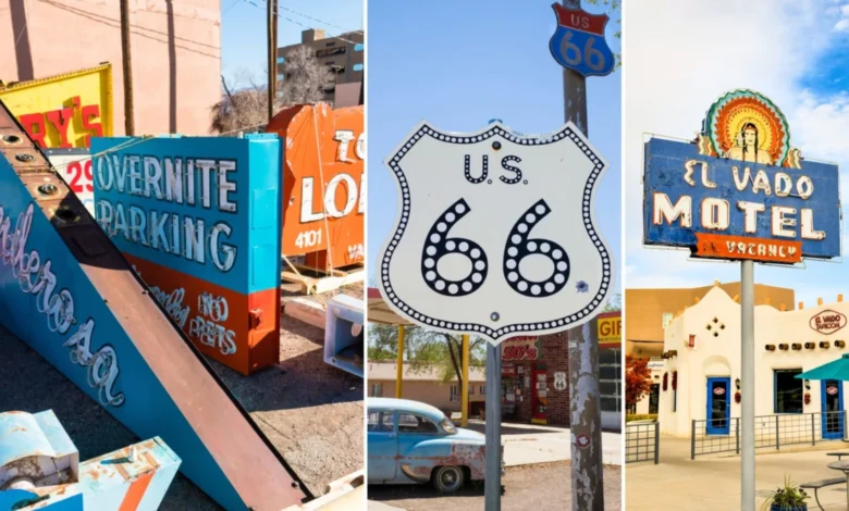
This realignment spurred a construction boom in the mid-20th century, leading to the proliferation of the motor hotels (motels) and neon signage that define the route’s aesthetic today. Many of these structures, characterized by Pueblo Deco and Streamline Moderne architecture, have become protected landmarks.
Chronology of a Six-Hour Urban Trek
Hour 1: The Western Gateway and Motel Row
The exploration begins on the western edge of the city, where the highway maintains its mid-century character. This section is densely packed with historic motels that have recently seen renewed investment through the National Park Service Route 66 Corridor Preservation Program.

Notable landmarks include the El Don Motel, recognizable by its neon cowboy swinging a lasso, and the El Vado Motel. Built in 1937, the El Vado is a prime example of the Spanish Tile-roofed, adobe-style architecture that was marketed to tourists seeking an "authentic" Southwestern experience. After falling into disrepair, the El Vado was renovated in 2018 as a mixed-use space featuring boutique lodging and a "food pod," illustrating the city’s strategy of adaptive reuse to preserve historic assets while meeting modern consumer demands.
Hour 2: Indigenous Art and the Trading Post Economy
As the road curves into the heart of the city, it passes the Rio Grande Trading Post. This institution represents the long-standing economic relationship between Route 66 tourism and Indigenous communities. The trading post serves as a major hub for Navajo (Diné), Zuni, and Hopi artisans, selling traditional sand paintings, wampum beads, and silver jewelry to hundreds of stores across the country.

Further east, Duran’s Central Pharmacy highlights the longevity of local businesses along the route. Established in 1942, it functions as both a community pharmacy and a restaurant famous for its red and green chile. Such establishments provide a sense of continuity in an urban landscape that has undergone significant demographic and architectural shifts over the last 80 years.
Hour 3: The Cinematic Influence and "Set-Jetting"
The middle section of the walk enters the territory of modern pop-culture landmarks. The Dog House, a drive-in hot dog stand, has become a site of "set-jetting" tourism due to its prominent appearances in the television series Breaking Bad and Better Call Saul. New Mexico’s film industry, bolstered by significant state tax incentives, has turned local businesses into global icons.

According to the New Mexico Film Office, the industry contributed over $850 million to the state’s economy in the 2022 fiscal year. For Route 66, this cinematic fame has provided a new layer of relevance, attracting younger travelers who might otherwise be indifferent to 1950s nostalgia. Nearby, Good Medicine Tattoo, housed in a former filling station, exemplifies how younger entrepreneurs are reclaiming historic Route 66 infrastructure for creative industries.
Hour 4: Downtown Revitalization and Public Art
The downtown segment of Route 66 is currently undergoing a transition. The Arrive Hotel, a recent addition to the corridor, signals a push for high-end redevelopment. In front of such modern establishments, public art installations like "Alebrijes & Nahuals"—towering Mexican sculptures of spirit guides—connect the road to the city’s deep Hispanic and Latin American roots.

However, this area also presents the most visible evidence of the city’s social challenges. Long-time residents and business owners, such as those at the local 2nd Street thrift shops, note the increasing presence of unhoused populations and the complexities of urban policing. The "Mother Road" here is not just a tourist trail but a frontline for issues of urban poverty and infrastructure neglect.
Hour 5: The Intersection of History and Higher Education
Approaching the University of New Mexico (UNM), the atmosphere shifts. The campus, which sits directly on Central Avenue, brings a steady flow of student traffic. This segment features the 66 Diner, a quintessential roadside attraction housed in a converted 1940s warehouse. Despite the rain and wind that often characterize the high-desert climate, the area remains a hub of activity.

The city’s implementation of the Albuquerque Rapid Transit (ART) bus system along this stretch has been a point of contention. While designed to modernize the corridor and improve transit, the construction phase significantly impacted small businesses, and the dedicated bus lanes have altered the traditional "cruising" feel of the historic highway.
Hour 6: The "Greetings from Burque" Mural and Nob Hill
The journey concludes in Nob Hill, perhaps the most vibrant and preserved section of the route. The district is home to the "Greetings from Burque" mural, a popular photo spot that uses postcard-style font to celebrate the city’s nickname. Nob Hill was the city’s first suburban shopping fringe, developed in the late 1940s, and it retains a high concentration of neon signs and independent boutiques.

Economic Data and the 2026 Centennial
As the 2026 Centennial approaches, federal and state agencies are ramping up investment. The Route 66 Centennial Commission Act, signed into law in 2020, established a body to plan celebrations and preservation efforts. In New Mexico, the Tourism Department has identified Route 66 as a primary driver for international visitation, particularly from European and Asian markets where the mythology of the American West remains a powerful draw.
Data from the National Trust for Historic Preservation suggests that heritage travelers stay longer and spend more than the average tourist. For Albuquerque, this translates to millions of dollars in potential revenue from lodging, dining, and retail along the Central Avenue corridor.

Social Implications and Analysis
The walk across Albuquerque’s Route 66 reveals that the road is a "palimpsest"—a surface where multiple layers of history are visible at once. The romanticized 1950s version of the road exists alongside the 19th-century Indigenous history and the 21st-century realities of urban renewal.
While the city has launched campaigns like "Stop Bagging, Start Bragging Albuquerque" to improve the city’s self-image and combat negative perceptions of crime and poverty, the physical experience of the road suggests that preservation must go beyond neon signs. True revitalization requires addressing the needs of the people who live and work in the shadow of the historic motels.

The city’s Route 66 Tourist Office continues to provide maps and historical context, emphasizing the "Mother Road" as a symbol of resilience. The office encourages "slow travel," arguing that by slowing down—or even walking—travelers can appreciate the architectural details and human stories that are lost at 40 miles per hour.
Conclusion: The Road Ahead
Route 66 in Albuquerque is more than a nostalgic squiggle on a map; it is a critical economic and cultural corridor. As the city prepares for the 2026 Centennial, the focus remains on balancing the needs of a modern metropolitan area with the preservation of a global icon. Whether through the lens of a camera, the window of a classic car, or the soles of a pair of walking shoes, the Mother Road continues to offer a unique perspective on the American experience—one that is as much about the challenges of the present as it is about the poetry of the past.